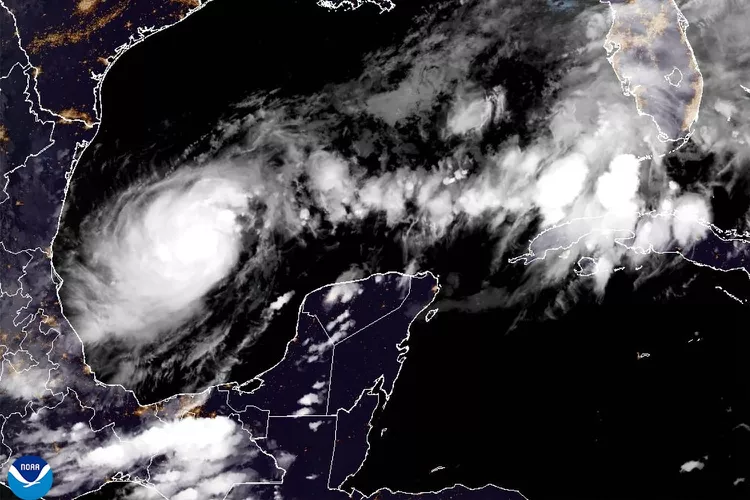
After making its way across the Gulf of Mexico, where it has been gaining strength, Hurricane Milton is anticipated to make landfall in the United States on the western coast of Florida probably late on Wednesday, October 9, or early on Thursday, October 10. This is the first time that it is projected to make landfall in the United States.
According to projections made by the National Hurricane Center, Hurricane Milton would bring “life-threatening” risks to the western coast, as well as to the central and southern regions of Florida, with the Tampa Bay area serving as the focal point.
After making landfall in the Big Bend area of northern Florida late on September 26, Hurricane Helene proceeded to carve a trail of devastation across the Southeast and claimed the lives of more than 200 people. The region is currently in the process of recuperating from the effects of Hurricane Helene.
Residents of Florida are getting ready for the storm, and they can follow live updates on the course that Milton will take, the most recent prediction, and news from the ground.
According to a statement released by the National Hurricane Center on Wednesday, October 9, it is anticipated that Hurricane Milton would “remain an extremely dangerous major hurricane when it reaches the west-central coast of Florida.”
Milton continued to be a Category 5 hurricane with winds reaching at nearly 160 miles per hour, according to the statement issued at five in the morning.
“According to the forecast track, the center of Milton will move across the eastern Gulf of Mexico today, make landfall along the west-central coast of Florida late tonight or early Thursday morning, and then move off the east coast of Florida over the western Atlantic Ocean Thursday afternoon,” the National Hurricane Center (NHC) noted.
From this evening until early Thursday morning, the National Hurricane Center (NHC) said, “Hurricane conditions are expected to be present in the hurricane warning area across the state of Florida.” The warning region on the east coast of Florida is projected to see the beginning of tropical storm conditions tonight, and the conditions are expected to begin along the coast of Georgia on Thursday.

On Tuesday, October 8, the National Hurricane Center made the announcement that satellite photos showed that Milton’s maximum sustained winds climbed to close to 165 miles per hour, therefore reclassifying it as a category 5 storm.
Their statement went on to say that while there is a possibility that the strength of Hurricane Milton would fluctuate as it proceeds over the eastern Gulf of Mexico, it is anticipated that Hurricane Milton will be a dangerous major hurricane when it approaches the west-central coast of Florida on Wednesday night.
The Meteorologist Who Became Famous Gives His Opinion
13 hours and 33 minutes agoThe link to this blog post should be copied.
John Morales, a veteran meteorologist, shared with PEOPLE that he had just discovered that the storm had momentarily achieved Category 5 classification at the time of his viral broadcast, in which he shed tears while reporting live on the potential destruction that may be caused by Milton.
“The wind speeds more than tripled in the span of just over 24 hours,” according to the researcher.
“After that, I am observing the barometric pressure, which is a measurement of the intensity of the hurricane,” he continues, “and I am observing a precipitous drop in the pressure.” Just before I turn to the camera and begin to speak, I am mentally doing a calculation. When I mention that the pressure has decreased by fifty millibars in ten hours, which is a significant amount of pressure for a meteorologist, my voice cracks.
As far as Morales is concerned, he has never been an alarmist when it comes to his weather predictions; rather, he has always been a “just the facts” man throughout his extensive career.
“In a television market where tropical weather is hyped up to an enormous degree,” he adds, “people truly appreciate that.” “Throughout my whole life, I have always been the one who goes against the flow, and I am the person who does not exaggerate things to an excessive degree. And yet, all of a sudden, people seen that response from me the day before, and I believe it is one of the reasons why I apologized. However, this is also one of the reasons why it became viral.
According to a statement released by Disney World, beginning on Wednesday, October 9, all of the “theme parks and Disney Springs will be closed in phases.”
With the exception of Magic Kingdom park, EPCOT, and Disney Springs, which will shut at two o’clock in the afternoon, Disney’s Hollywood Studios and Disney’s Animal Kingdom will close at one o’clock local time.
There is a high probability that the amusement parks will continue to be closed on Thursday, October 10]. After that, the statement said, “We will consider opening Disney Springs on Thursday in the late afternoon, with limited offerings.”
Furthermore, Busch Gardens Tampa Bay and Universal Orlando will both be shutting their doors.
In an effort to keep people informed, the White House has launched a Reddit account.
15 hours and 45 minutes agoThe link to this blog post should be copied.
The White House made the announcement on Tuesday, October 2, that they would be launching a Reddit account in order to keep people updated about their continuing efforts to react to and prepare for the earthquake that occurred in Milton.
The Biden-Harris Administration and the Federal Emergency Management Agency (FEMA) are working together, according to a White House official, to identify and address the continuous disinformation that surrounds Milton and Helene.
It has been announced that the page, which is currently operational, will include material from local Subreddits. Additionally, a White House official has said that their postings would be published on bigger sites such as r/politics.
As Florida braces for Milton, Walt Disney World remains open — but the Orlando resort is already making adjustments to “some areas with unique environments” in anticipation of the storm.
At 6.p.m. local time on Monday, Oct. 7, Disney World announced that its more rustic accommodations will be closed ahead of the storm. Fort Wilderness Resort & Campground (including dining and recreation locations), the Copper Creek Cabins at Wilderness Lodge, and the Treehouse Villas at its Saratoga Springs Resort & Spa will temporarily close beginning at 11 a.m. on Wednesday.
The update added that Fort Wilderness Resort & Campground and the Treehouse Villas at Disney’s Saratoga Springs Resort & Spa will likely stay closed until Sunday, Oct. 13, and that the Copper Creek Cabins at Wilderness Lodge are likely to reopen on Friday, Oct. 11.
Disney did not make any announcements regarding its other resort hotels or the parks, which as of Tuesday morning remain open. It’s possible Disney will make additional closure announcements as the storm approaches.
Similarly, Universal Orlando said Tuesday morning that park operations and hours were “continuing as normal,” adding, “We are closely monitoring the weather. Please check back for updates.
A mother from Florida is revealing her thoughts on TikTok after reacting to remarks over the manner in which her family is getting ready for Milton.
The mother of six, who goes by the moniker @mamamossof6, says in the video that she and her family feel trapped in Florida, despite the fact that earlier comments advised her to leave the state while she was in Florida.
She continues by saying that her family is as well prepared as they possibly can be, considering all that has happened. They are equipped with a generator, gas, and windows that are hurricane-proof. “We have come up with what we can,” she adds. “The only thing we can’t control is the storm surge.”
As a result of the fact that they are located in Zone A, which is the first zone that is normally evaluated for evacuation, she goes on to say that in the event that they are had to evacuate, they will look for a location that is located inland.
Although there have been some articles on social media that have gone viral saying otherwise, it is not conceivable for Milton to intensify to the point where it might become a so-called Category 6 hurricane. The intensity of the storm has varied as it passes across the Gulf of Mexico.
Due to the fact that the Saffir-Simpson Hurricane Wind Scale only includes five categories of hurricanes based on sustained wind speed, there is no such name for one.
Anything that comes after a hurricane hits the Category 5 level does not adequately convey the level of destruction that it is capable of.
“There is no reason to add a Cat 6 because a Cat 5 is already total destruction,” claimed a meteorologist on social media. “There is no reason to add to the mix.”
In an update that was released on Tuesday, October 8, Governor Ron DeSantis issued a warning to the people of Florida to be ready in the event that Hurricane Milton deviates from its first estimated route.
“Compared to what was previously anticipated, the storm has advanced at a somewhat slower pace. But keep in mind that you should not become married to the cone,” he said. “Do not get married to the location where the landfall is expected to occur… You can experience a wobble in any direction.
He said that the storm is expected to make landfall in the Bradenton Beach and Manatee County region on Wednesday evening or early Thursday morning, according to forecasts that were made at five a.m. local time. However, if the storm changes, the Tampa Bay area may also experience effects.
He advised individuals who were both within and outside of the expected cone of the cyclone to make sure that they were ready for the hurricane.
“Now is the time when you have the ability to make the decisions necessary to keep yourself and your family safe,” DeSantis said. “You have the ability to make these decisions.” We strongly encourage you to carry out your strategy. Right now. Let’s get ready for the worst, pray that we get weaker, and hope that the least amount of damage is possible; nonetheless, we must be ready for a huge, major impact to the west coast of Florida. Let’s prepare for the worst.
On Tuesday, October 8, the National Weather Service provided an update in which it said that Milton had advanced to the status of a “powerful category 4 hurricane.” However, the service also issued a warning that “fluctuations in intensity are expected.”
According to the statement, the maximum sustained winds of storm Milton are now close to 155 miles per hour, and it is anticipated that the storm will continue to be a very dangerous hurricane until it makes landfall in Florida.
It is also anticipated that Milton will proceed to the north of the Yucatan Peninsula on Tuesday, as stated by the National Weather Service, and that it will make landfall on the west coast of Florida on Wednesday night.
The National Weather Service has issued a warning that “If the storm stays on the current track, it will be the worst storm to impact the Tampa area in over 100 years.” This warning comes as a result of the storm’s current trajectory.
The authorities also asked the residents in the area to complete their preparations by Tuesday, October 8, and to “evacuate if told to do so.”
According to the National Weather Service, there is a forecast that indicates that the danger of flooding, wind, and storm surge will spread throughout a significant portion of central and southern Florida.
Jane Castor, the mayor of Tampa, reportedly informed reporters that “this is the real deal here with Milton.” This information was reported by the Associated Press. If you engage in a battle with Mother Nature, you should know that she is always victorious.
According to an update provided by the National Hurricane Center on Monday afternoon, Milton had, as anticipated, developed into a Category 5 hurricane, with sustained winds reaching a maximum of 160 miles per hour.
The forecasters have predicted that Milton would become less powerful as it approaches the point where it will make landfall; nonetheless, it is still anticipated to be very hazardous.
When asked to evacuate, officials say, “Please” evacuate.
It is 11:37 AM on October 7th, 2024. Copy of EDTCopy This blog post’s link to the article
The director of the National Hurricane Center issued a call to action to residents of Florida in advance of the arrival of Hurricane Milton this week, which is expected to take place on Wednesday evening.
In his words, “Get ready.”
Michael Brennan issued the following statement to ABC News: “If you live in a storm surge evacuation zone and your local officials ask you to leave, please comply with their request by leaving.” “You don’t have to drive hundreds of miles to get to a safe place, often just tens of miles to get inland — out of that evacuation zone, to a shelter, a friend or loved one’s home.”
Based on the most recent forecast from the National Hurricane Center, which was released on Monday, it is anticipated that Hurricane Milton will move across the Gulf of Mexico and make landfall on the Yucatan peninsula in Mexico later on Monday. After that, it will move back into open ocean on Tuesday and then move over Florida by Wednesday.
The course that is predicted, on the other hand, is not set in stone and will be reviewed and revised on a regular basis by forecasters.